
Issue Number 56
(November 2000)
![]()
Outback Queensland trip, August 2000
by Jean Weber
|
Issue Number 56 |
Outback Queensland trip, August 2000by Jean Weber |
| |
Eric and I took our first major motor home trip in July and August this year. Eric has written the trip up in considerable detail in his fanzine, Gegenschein 89. Rather than duplicate his level of detail, I'm including some brief summaries here, plus photos (Eric doesn't do photos). Most of the photos were taken with my Kodak DC-240 digital camera, but a few were scanned from prints made with Eric's little Pentax camera. Another version of this trip report is on our Avalook website. Photos albums are stored on Photopoint. If you've got a map of Australia, I suggest you get it out now and follow along. I've included a map in this zine. Others are available on the Web. One handy map is on the Queensland Main Roads site; it's where we look up road conditions. Cape HillsboroughWe started out from Airlie Beach on Monday, 7 August, and drove south towards Mackay, stopping for three nights at a "nature resort" caravan park at Cape Hillsborough National Park.
We ate dinners at the caravan park's excellent bar and restaurant. Photo: Wedge Island at low tide. |
| |
Clermont & Blair Athol MineFrom Cape Hillsborough we bypassed Mackay and got onto the highway heading southwest to Clermont. There wasn't much to do or see on the way, without diverting from the road. Clermont is in a major mining area, mostly coal but other materials as well. We stayed two nights at the Clermont Caravan Park, which was originally built by the Blair Athol Coal mine for its workers. This explains the unusually well-designed and spacious showers. The very interesting (and free) tour of the Blair Athol Mine included a stop at the local historical museum, with its collections of old household appliances, and other memorabilia. Eric kept pointing at things and saying, "I had one of those, and you made me throw it out!" AlphaWe skipped the gemfields (towns with names like Emerald, Sapphire, and Rubyvale) this trip, because the annual Gemfest was on that weekend, and all the campgrounds and motels were full. We could have camped in a field, but we're not keen on crowds, so we decided to come back another time.
Instead, we drove the back road from Clermont to Alpha, 170 km of crushed gravel, mostly in quite good condition. Alpha is located on the main highway that runs from Rockhampton west to Longreach. It is small but boasts several interesting murals painted on various buildings, including the public toilets. We wandered around a bit, but didn't stay long. And yes, there is a Beta marked on the map a few km away, but we couldn't find it. We assume it used to be a railway stop years ago. |
| |
Barcaldine and AramacBarcaldine (pronounced Bar-CALL-din), population now around 2,000, was established in 1886. Several major events took place here, including the founding of the precursors to two of Australia's major political parties. The Graziers Association (founded in 1889) later became the National Party, and the shearers' strike in 1891 led to the formation of the Workers Party, which later became the Australian Labor Party.
In addition to the six pubs on the town's main street, a historical museum, and various other sites, a major tourist attraction is the Australian Workers Heritage Centre, a large and impressive site with several buildings containing displays explaining the history of Australian workers and of the labour movement, including a railway station, school, power station, police, fire, and main roads. They are working on a major exhibit on women at work. Tom Lockie of Artesian Country Tours was a very audible presence around the camp fire at the caravan park each evening, telling stories and jokes, and obviously very familiar with the history of the entire area. We were so impressed that we stayed in town an extra three days just to go on his one-day tour to Aramac and nearby areas. We'll be writing that tour up in more detail for the Avalook website, so I'll just say here that we enjoyed it thoroughly and learned a lot.
Photo left: Rock wall at a campsite used by sheep and cattle drovers in Aramac area Aramac was the first town settled in the area. At one stage in the 1800's, some hugely impressive volume of wool was being shipped out of the area on huge horse- or bullock-drawn wagons. Tom Lockie said that Aramac was then as well known as Sydney, and people around the world knew it was in Australia—even if they had no idea where Australia was!
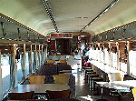
Photo right: Dining car on train Before leaving Barcaldine the next day, we went to the railway station at 8:30 am to see the twice-weekly train, the Spirit of the Outback, come in from Longreach on its way to Rockhampton and Brisbane. We walked through several cars of the train to see the comfortable facilities. |
| |
IlfracombeWe stopped about 70 km up the road at Ilfracombe, originally called Wellshot, where for the first time since we left the coast, we could get a mobile phone signal. The 1911 Post Office was also the library, the toy library and the local internet access point. The tourist attractions included the 1898 Wellshot Pub, which has a daily 40 minute stockman act; and the machinery and heritage museum, which has a long string of heavy machinery stretching further than the town along the side of the road. The small museum itself is made from a station house. They have also preserved a 1901 police cell. After a few hours wandering around, we continued the 27 km into Longreach. LongreachLongreach is famous for several things, and we visited most of the major attractions. It was the first home base of Qantas Airlines (then known as Queensland and Northern Territory Aerial Services Ltd.), which has a small museum. The Australian Stockman's Hall of Fame is large and well done, tracing the history of outback Australia from the original Aboriginal inhabitants through the glory days of sheep, cattle, and mining, to the present time. Many events in Australian history, such as the gold rushes, occurred at about the same time (mid-18th century) and in much the same kind of dry, hot countryside as in the American West, so I felt I'd seen most of it before, but the differences are very interesting too. We also visited the Longreach School of Distance Education (formerly known as the School of the Air), and listened in to a few minutes of live chat between teachers and their young students on outback stations. The facilities for education of children far from any population centres are impressive. We spent two nights in Longreach, but found the caravan park a bit crowded, so we headed off to the bush for a few days. |
| |
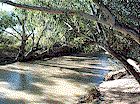
Bladensburg National ParkFrom Longreach we drove northwest along the Lansborough Highway (also known as the Matilda Highway) through gently rolling grassland to Winton, then turned south on a dirt road into Bladensburg National Park. Despite being confused by a lot of 4WD tracks running in all directions, we found the ranger's office (unattended), filled out a camping permit form, then found our way to the camping area.
Photo left: The waterhole by our campsite Surprisingly, no one else was there. It was a very pleasant spot, with one clean pit toilet, but you needed to bring everything else, including water. The campsite was by a rather muddy waterhole, and we could hear the occasional moo and baa in the underbrush, but we saw no wildlife except for quite a few birds (and flies). It was such a nice, quiet spot that we stayed for two nights, despite the lack of a shower. During the day three vehicles came by but no one else stayed overnight.
On the second day, as we drove back to Winton, we stopped to look at two other waterholes in the area, one in a gorge. We decided against taking the dirt track to Lark's Quarry to see the dinosaur stampede tracks, although they sound well worth a visit. WintonThe Winton district was settled in 1873 when rural properties, including Bladensburg, were founded. Originally known as Pelican Waterhole, the town claims that Banjo Paterson's Waltzing Matilda had its first public performance on 6 April 1895 in the North Gregory Hotel (which has burnt down and been rebuilt at least twice since then). The first board meeting of Qantas was also held in the town, in 1921. The Bronze Swagman Bush Poetry competition has been held there since 1972.
Photo: Arno's Wall, showing 2 complete motorcycles embedded in it |
| |
KynunaWe stopped for the day at the tiny town of Kynuna (population between 12 and 18) and stayed at the Jolly SwagVan caravan park run by the historic Blue Heeler Hotel, where the last brawl of the Shearer's Strike of 1891 was settled. We paused to admire the sign of a blue heeler (dog) with the flashing red neon tongue on top of the pub. We were one week too early for the annual surf carnival, in aid of the Royal Flying Doctor Service, where lifeboats parade the street, hundreds of kilometres from the nearest surf. (Yet more fannish-style activity!) McKinlay
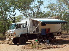
Photo: Walkabout Creek Hotel CloncurryOn to Cloncurry, on the main road west from Townsville to Mt Isa and the Northern Territory. Although it's not a large town (around 4,000 people), it was the biggest we'd see for a couple of weeks, so we stocked up on food and fuel. Local sights include a Flying Doctor Museum, an art gallery, a cultural centre, an outdoor theatre, and the Mary Kathleen Museum, containing memorabilia from the closed MK uranium mine. Burke and Wills Roadhouse
The road north of Cloncurry is a typical Queensland outback road, with one lane of bitumen (blacktop, asphalt) down the middle and half a lane of gravel or dirt on each side. You drive on the bitumen until you get within a few hundred metres of a vehicle coming in the opposite direction, then both vehicles dodge off onto the sides of the road (usually keeping their right tyres on the bitumen) until they've passed each other. Unless, of course, one vehicle is a road train—in this case, it's prudent for the other vehicle to get completely off the road and let the truck have the bitumen to itself.
Photo: road train |
| |
Gregory RiverFrom Burke and Wills, we headed west, still on a paved road (as described above), crossing the Leichhardt River on a fairly new, high-level bridge, from which we could look down on the old causeway across the river. As with most rivers in outback Queensland, the water level is low in the middle of the dry season, but you can easily see how high the water gets during the wet, quickly making the causeway impassable.
We checked the pub for dinner, and found they were doing a $10 all you can eat barbeque, with really great serves of salad, plus fish, steak, hamburger and snags (sausages). I guess having a road-building crew resident in the hotel helped encourage them to put on a big feed. |
| |
Lawn Hill National Park and Adel's Grove
10We could only visit Lawn Hill as day vsitors, as the camping area there was full. We took a few nice walks through forest to the Cascades and to Indarri Falls, but we didn't have the ambition to walk as far as the Upper Gorge or take a canoe through the Middle and Upper Gorges, but everyone said that was the best way to see the area. You can bring your own canoe or hire one there for quite reasonable rates. Photo right: A good way to see Lawn Hill Gorge is by canoe
We stayed overnight about 10 km away, at Adel's Grove, a spacious and nicely laid out camping area in wonderful grounds. Early in the morning, as we boiled the billy, an agile wallaby visited us, looking for a handout (no luck). This was such a pleasant place, and so few people were there, that we would have stayed another day or two, but we had people to meet at our next stop, so we went on the next day. |
| |
DoomadgeeAfter driving back over that dirt road to Gregory Downs, we continued north on on a much better dirt road. When we met the Great Top Road, we turned west. This road is considered 4WD only, and definitely would be in wet weather (if you could get through at all), but despite being fairly rough it was no problem at the time we visited. When we got to the Doomadgee turnoff, the road became much worse. We reached the town in late afternoon and sought directions to the hospital, where we were greeted by fans Craig and Julia Hilton. We stayed with them for several days, collecting our e-mail, washing clothes, and visiting. Doomadgee has a population of around 1500. It is on Aboriginal land, under the control of an Aboriginal council, and we had to apply to them for permission to stay. Sale of alcohol is banned in the town, so we were discreet about our supplies. Smuggling beer into town, and selling it at high prices, is a common practice. The town was run-down and I found it depressing, but the store had good stocks of fresh food, and Julia and Craig introduced us to some of the resident Aboriginal people who are trying to improve the town. There's little employment available locally, though some of the men work at the Pasminco Century zinc mine near Lawn Hill. The hospital is well-supplied and well-run, and has some of the videoconferencing gear that is being supplied to all Queensland regional hospitals. Craig uses this equipment to keep his patients (who have been transferred to larger hospitals in other places) in touch with their extended families. This is good for everyone's morale. He also uses it for conferences with specialist doctors, as an aid in diagnosis and treatment. |
| |
BurketownEventually we headed east to Burketown, where we checked out the pub and had some lunch.
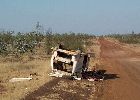
Shortly afterwards we crossed the Alexandria River, on the very rough (rocky) natural riverbed. Then on for many kilometres of rough road, through relatively boring gulf savannah country. Photo right: This car didn't make it The last 30km before the Normanton turnoff were very corrugated, so we were certainly happy to get back on the bitumen a few km south of Normanton (this is the direct route from the Burke and Wills roadhouse). |
| |
NormantonWhen we pulled up at the caravan park, we discovered that we had a broken stainless steel water tank, presumably caused by being bounced around for many kilometres. Fortunately we had two tanks and could close the connection between them. Also fortunately we were not heading into country where we needed a lot of water onboard. For dinner, we decided the very visible Purple Pub wasn't us, but we had been advised to try the Central Hotel. The food was delicious and plentiful. We had barramundi, our favorite fish, as we were in the heart of barra country.
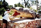
One attraction in town in Krys, a full size model of a 28-foot 4-inch saltwater crocodile with a girth of 13 feet. The real croc had been shot by crocodile hunter Krystina Pawloski in the Norman River in July 1958. Photo right: Jean and Krys the crocodile KarumbaFrom Normanton, we traveled the good bitumen road 70 km to Karumba Point, on the sea overlooking the Gulf of Carpentaria. This is the centre of the prawning industry, and nearby is the shipping terminal for the zinc from the Pasminco Century mine. The big tourist attraction is fishing, and there are several charter boats available. The caravan parks were crowded and looked difficult to get our truck into, so we booked into a motel unit across the street from the Sunset Tavern for two days.
Photo left: Sunset Tavern at Karumba Point. The sign on the roof (facing the sea) says "Ice Cold Beer". Photo right: Sunset as seen from the tavern, with pelicans in the foreground.
Photo: Fishing at Karumba Point |
| |
Croydon and GeorgetownFrom Karumba we returned to Normantown, then drove to Croydon and on to Georgetown. The map showed some dirt on this stretch, but the road is now paved all the way. Founded around 1886, Croydon is now a small historical village of less than 400 people, with several mining museums. Little remains of the large gold mining city it was over a century ago, when the population peaked at 8,000 and there were 26 pubs. It is the eastern terminal of the Gulflander train from Normanton. In Georgetown, we stayed at the Midway Caravan Park. Their little shop sold an amazing variety of goods and services, being a service station, very decent cafe, lottery agent, video shop, pharmacy and photolab -- and they had accommodation and a swimming pool. Georgetown had also been a gold town, and with a fossicking permit you can still search for nuggets; now and then someone finds one. However, the town didn't seem to offer much else (though there was internet access at the public library). Mt SurpriseAnother 100 km of narrow road brought us to Mt Surprise, one of the stations for the Savannahlander train (a different one from the Gulflander, but another that's a tourist train rather than a way to get from one place to another). Other than the train stations, there were two service stations and a few small museums, which appeared to be closed. UndaraWe reached Undara, famous for its lava tubes, just after lunch time, after only 15 km of corrugated dirt road off the main road. The main crater of this system of over 160 craters was formed 190,000 years ago. The lava flowed through the mostly flat terrain and along old river beds. The surface solidified while lava continued to flow. The flow was such that many of the tubes emptied themselves of lava when the flow ended, leaving huge hollowed-out lava tubes. The longest tube was 160 km long.
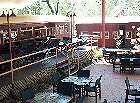
Photo left: Outdoor dining area, constructed as a train station with platforms. Photo right: Our motorhome in the Undara campground
We took an extra rest day at Undara, which was such a pleasant place that we considered staying longer. However, we were now within two days' drive from home, and I in particular wanted to get there, so we went on. |
| |
Charters TowersThe mostly empty road to Charters Towers is another one-paved-lane job. After passing Lynd Junction, we came upon the former mining town of Greenvale. The Three Rivers Hotel had a great collection of hubcap clocks on the walls. They were trying to make up a museum for crossword puzzles, and had some really great ones on display. On to Bluewater Springs for another cooling drink. After a long day's drive (at 70 kph, distances seem rather longer than in the car), we finally reached Charters Towers. For the first time since Longreach, our mobile phones could pick up a signal. We were now officially back in civilisation! We did no sightseeing in Charters Towers this trip, but drove on the next day, bypassing Townsville (which we visit often) and getting home by early afternoon. Some general observationsThe roads were mostly better than we expected, although a few were in very rough condition. Except for parts of the Gulf Savannah country, we could have done the whole trip in a conventional (non-4WD) vehicle. The road from Cloncurry to Normanton is paved all the way (though only one lane), so we could have had a good taste even of the Gulf country. More places than we expected had hotel or motel rooms, although many of those were of the shared-facilities variety, and could easily be taken, especially if a tour group came through. But we could bring a tent to use if needed, and stay in motel rooms most of the time if we wanted to. Public pay phones are readily available, but few accommodation units have phones in the rooms. Internet access is commonly available, though often at restricted times, but finding some place to connect one's own computer to the phone lines is generally not easy. Mobile (cellular) phone access is almost non-existent away from major towns. Food was plentiful and mostly good to great in the pubs and roadhouses along the way. We only cooked dinner once the whole trip, preferring to let someone else do the work. In all, the trip we took was considerably less rugged than it would have been 20 years ago, though parts of it would still be difficult if not impossible in wet weather. Of course, there were many places we could have gone off the main roads, where we would have needed the 4WD, but we didn't have good enough maps or the necessary experience in off-road driving, so we didn't go to those places. Perhaps another year? We had nearly perfect weather for the trip, but we can't count on that. It wasn't too hot, or too cold, or too humid; very little rain fell (a problem for the farmers, but nice for us); and no windstorms occurred. However, we did drive too far in the 4-1/2 weeks, and we didn't spend enough time just being lazy and enjoying the experience. We also didn't do enough bush camping, preferring to have electricity and the use of someone else's shower and toilet. Our motorhome is self-contained, but it's a bit cramped. The solar power system and batteries would give us enough power for several days' use, even with my computer on for several hours a day, but we didn't push it.
Home | Contents issue 56 | Outback trip | Diary notes | Book notes | Lyn's Farming Daze | Letters | Writing test Brought to you by: Jean Weber Page last updated 29 March 2002 |
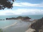 We took several interesting walks, including a boardwalk through the mangroves, a nature trail through various woodlands (with a view of an Aboriginal fish trap), a steep hike up a hill to get great views of the whole area, and a walk at low tide to a nearby island.
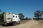 Photo: Back road from Clermont to Alpha
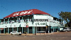 Photo: The Globe, one of the six pubs on Shakespeare
Street, Barcaldine
Photo: The Globe, one of the six pubs on Shakespeare
Street, Barcaldine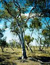
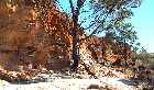 Photo right: countryside in
Aramac area
Photo right: countryside in
Aramac area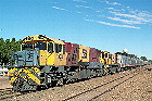
 Photo
left: Spirit of the Outback train.
Photo
left: Spirit of the Outback train. 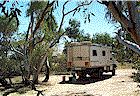
 Photo
right: Our campsite at Bladensburg NP.
Photo
right: Our campsite at Bladensburg NP. 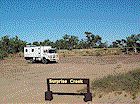
 Photo
left: Surprise Creek, a wide dry bed—no doubt a surprise after sudden
rain.
Photo
left: Surprise Creek, a wide dry bed—no doubt a surprise after sudden
rain.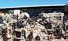 One
of the stranger sights in Winton is Arno's Wall, made of metal, plastic,
ceramic and other junk from the tip (dump) held together with concrete.
Among other cast-off materials are two motorcycles, artistically arranged.
A truly fannish work of art!
One
of the stranger sights in Winton is Arno's Wall, made of metal, plastic,
ceramic and other junk from the tip (dump) held together with concrete.
Among other cast-off materials are two motorcycles, artistically arranged.
A truly fannish work of art! After
Kynuna we drove to Mckinlay, notable only because it has the Walkabout
Creek hotel used in the Crocodile Dundee movies. Naturally we had to stop
and have a drink there. There was virtually nothing else in the town.
After
Kynuna we drove to Mckinlay, notable only because it has the Walkabout
Creek hotel used in the Crocodile Dundee movies. Naturally we had to stop
and have a drink there. There was virtually nothing else in the town.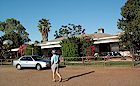 We
continued on north, stopping at the Quamby pub for a soft drink, and then
on to the Burke and Wills Roadhouse, where we stayed overnight at their
caravan park. We had a really nice lamb chop dinner (and a few beers)
on their verandah. Photo: Burke and Wills Roadhouse
We
continued on north, stopping at the Quamby pub for a soft drink, and then
on to the Burke and Wills Roadhouse, where we stayed overnight at their
caravan park. We had a really nice lamb chop dinner (and a few beers)
on their verandah. Photo: Burke and Wills Roadhouse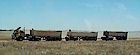 Although
our motorhome isn't as big as a road train, we did notice a tendency for
most smaller vehicles to get off the road when they saw us coming—possibly
to avoid being hit by any stones we might kick up (surely it's not our
erratic driving).
Although
our motorhome isn't as big as a road train, we did notice a tendency for
most smaller vehicles to get off the road when they saw us coming—possibly
to avoid being hit by any stones we might kick up (surely it's not our
erratic driving).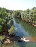 Photo
left: Leichhardt River as seen from new high-level bridge, showing old
low-level crossing.
Photo
left: Leichhardt River as seen from new high-level bridge, showing old
low-level crossing.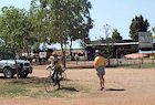 Eventually
we reached the Gregory River, where there was Billy Hanger's general store
and canoe hire and the Gregory Downs Hotel. The toilets and showers across
the road were a bit primitive. This is not a complaint, just an observation.
You get used to corrugated iron sheds after awhile, and it's part of the
outback experience. At least the shower water was hot, the toilet flushed,
the place was clean, and there was a bench on which to put your clean
clothes; what more do you need? Photo: General store at Gregory River
Eventually
we reached the Gregory River, where there was Billy Hanger's general store
and canoe hire and the Gregory Downs Hotel. The toilets and showers across
the road were a bit primitive. This is not a complaint, just an observation.
You get used to corrugated iron sheds after awhile, and it's part of the
outback experience. At least the shower water was hot, the toilet flushed,
the place was clean, and there was a bench on which to put your clean
clothes; what more do you need? Photo: General store at Gregory River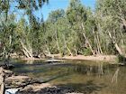 We'd
been told from people who'd stayed there last year that the Gregory River
bed (a few hundred yards from the Hotel) was a very nice place to camp,
so we stayed there overnight. Unfortunately, this year a new bridge is
under construction, and half the camping area is occupied by earth-moving
machines making lots of noise. Despite this, there were over a dozen caravans,
tents and motorhomes already camped there, taking all the good spots by
the river. We walked along the river for awhile, and it did look very
pleasant, with nice swimming holes (and no crocodiles). Photo: Gregory
River at camping area
We'd
been told from people who'd stayed there last year that the Gregory River
bed (a few hundred yards from the Hotel) was a very nice place to camp,
so we stayed there overnight. Unfortunately, this year a new bridge is
under construction, and half the camping area is occupied by earth-moving
machines making lots of noise. Despite this, there were over a dozen caravans,
tents and motorhomes already camped there, taking all the good spots by
the river. We walked along the river for awhile, and it did look very
pleasant, with nice swimming holes (and no crocodiles). Photo: Gregory
River at camping area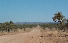 Unimpressed
with the bridge constuction, we declined to stay another day at Gregory
River, so we drove the 100 km of dirt road to Lawn Hill National Park.
The condition of this road varied from fairly smooth to bone-jarringly
rough, so we drove very slowly and took nearly 3 hours to get there. People
in smaller vehicles with better suspension were making better time. Photo:
Road to Lawn Hill
Unimpressed
with the bridge constuction, we declined to stay another day at Gregory
River, so we drove the 100 km of dirt road to Lawn Hill National Park.
The condition of this road varied from fairly smooth to bone-jarringly
rough, so we drove very slowly and took nearly 3 hours to get there. People
in smaller vehicles with better suspension were making better time. Photo:
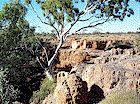
Road to Lawn Hill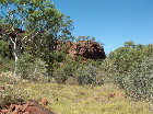 Photo
left: Rock formations in Lawn Hill National Park
Photo
left: Rock formations in Lawn Hill National Park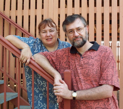 Photo:
Craig and Julia Hilton
Photo:
Craig and Julia Hilton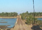
 East
of Burketown the road gets worse. We went off the road to check out the
camping sites at Leichhardt Falls, but the sand and the presence of several
caravans (and some large crocodiles sunbathing on a sandbar in the river)
didn't inspire a stay. No facilities there, and the crocodiles meant no
swimming. The river crossing was exciting as the causeway was very little
wider than the truck. Photo left: A typical river crossing.
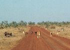
Photo right: Cattle on road—just one of many hazards.
East
of Burketown the road gets worse. We went off the road to check out the
camping sites at Leichhardt Falls, but the sand and the presence of several
caravans (and some large crocodiles sunbathing on a sandbar in the river)
didn't inspire a stay. No facilities there, and the crocodiles meant no
swimming. The river crossing was exciting as the causeway was very little
wider than the truck. Photo left: A typical river crossing.
Photo right: Cattle on road—just one of many hazards.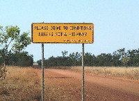
 Photo
left: Warning sign: Please drive to conditions; this is not a highway
Photo
left: Warning sign: Please drive to conditions; this is not a highway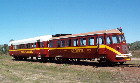
 One
of Normanton's major attractions is the Gulflander train trip. We didn't
want to take the full trip to Croydon (about 94 miles), stay overnight,
and ride back, although it sounded very interesting (they deliver the
mail to stations along the way), so we were pleased that the next day's
trip was a short one, just 16 miles each way. We enjoyed the trip thoroughly,
although it was quite bumpy. Photo left: The Gulflander train
One
of Normanton's major attractions is the Gulflander train trip. We didn't
want to take the full trip to Croydon (about 94 miles), stay overnight,
and ride back, although it sounded very interesting (they deliver the
mail to stations along the way), so we were pleased that the next day's
trip was a short one, just 16 miles each way. We enjoyed the trip thoroughly,
although it was quite bumpy. Photo left: The Gulflander train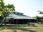
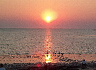 Sunset
Tavern, on the point, was the place for the evening. The sea coast is
such that you look west and can watch the sun set in a blaze of red across
the Gulf of Carpentaria. This was helped by yet another barramundi dinner,
and a bottle of wine.
Sunset
Tavern, on the point, was the place for the evening. The sea coast is
such that you look west and can watch the sun set in a blaze of red across
the Gulf of Carpentaria. This was helped by yet another barramundi dinner,
and a bottle of wine.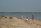 Karumba
Point is a pleasant spot. A walk along the shore just after dawn revealed
dozens of people comfortably set up for a morning's (or a day's) fishing.
The local pelicans kept an eye on them and came along at sunset to inspect
the crab traps as they were emptied.
Karumba
Point is a pleasant spot. A walk along the shore just after dawn revealed
dozens of people comfortably set up for a morning's (or a day's) fishing.
The local pelicans kept an eye on them and came along at sunset to inspect
the crab traps as they were emptied.
 We
dined at the Undara Lava Lodge. Much of the lodge, including the accommodation
units, the restaurant and bar, is constructed of renovated railway carriages.
Permanent tents are also available, as well as space for caravans, motorhomes,
and tent camping. At the time we visited (early September), the campground
was almost empty. We're not sure why everyone gave up earlier than usual
in the season, because the weather was quite pleasant.
We
dined at the Undara Lava Lodge. Much of the lodge, including the accommodation
units, the restaurant and bar, is constructed of renovated railway carriages.
Permanent tents are also available, as well as space for caravans, motorhomes,
and tent camping. At the time we visited (early September), the campground
was almost empty. We're not sure why everyone gave up earlier than usual
in the season, because the weather was quite pleasant.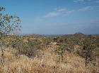
 Thomas
Atkinson, grandson of the geologist who wrote up some of the details of
the tubes, took us on both the morning and afternoon tours and told us
a lot about the history and geology of the area. We were the only people
on the afternoon tour. In addition to the lava tubes, we saw lots of wallaroos,
some emus, cave cockroaches and bats. Some of the mineral patterns on
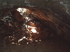
the walls and ceilings of the tubes are really striking. Photo left:
Countryside around Undara, with remnant of a volcano in distance.
Photo right: Inside a portion of a lava tube.
Thomas
Atkinson, grandson of the geologist who wrote up some of the details of
the tubes, took us on both the morning and afternoon tours and told us
a lot about the history and geology of the area. We were the only people
on the afternoon tour. In addition to the lava tubes, we saw lots of wallaroos,
some emus, cave cockroaches and bats. Some of the mineral patterns on
the walls and ceilings of the tubes are really striking. Photo left:
Countryside around Undara, with remnant of a volcano in distance.
Photo right: Inside a portion of a lava tube. 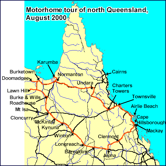